
History of Amendments by the Ministry of Transportation and Infrastructure and Ministry of Municipal Affairs
| Version | Date | Amendment |
| 2.0 | March 8, 2024 | Density Bonus: Clarity for local government regarding
the use of Density Bonus tool in
TOAs, and flagging that local governments should be periodically
checking the Local Government Density Initiatives website for more information. Compliance: Notification from local government to the Ministry of Transportation and Infrastructure on final adoption of the bylaw that is compliant with TOA requirements, including a copy of the bylaw. |
| 3.0 | May 29, 2024 | Categories of Transit Stations: Clarification on the identification of transit stations.
Off-Street Parking for Residential Use: Clarification on revisions for parking that local government must adopt a bylaw by the June 30, 2024. A copy of the Bylaw can be sent to the Ministry of Transportation and Infrastructure via email. |
| 4.0 | February 19, 2026 | Relationship with Other Provincial Initiatives: This section was updated to reflect 2024 legislative amendments (Bill 16). This legislation established the Inclusionary Zoning tool, updated the Density Bonus tool, introduced site-level infrastructure and transportation demand management (TDM) authorities, and established Tenant Protection Bylaw authorities. This section was also revised to include references to new and updated provincial guidance related to other requirements and tools.
Tense and Terminology Updates: Revised tense and terminology throughout the document to align with current legislative conditions and promote consistency. These revisions were non-substantive. |
Table of Contents
What are Transit-Oriented Areas?
Overview of the Minimum Density Framework
How should this Provincial Policy Manual be used?
Provincial Policy Manual Structure
Part 1 – Overview of the Legislation and Regulations
Why is the Province introducing Transit-Oriented Area requirements?
What do the legislation and regulations do?
How were TOAs defined and identified?
Location Exemptions and Future Considerations
What are the minimum density requirements in TOAs?
What are the new revisions that apply to off street parking for residential uses within TOAs?
Relationship with Other Provincial Legislation
Relationship with Other Provincial Initiatives
Linkages Between Official Community Plans and Zoning Bylaws
Small Scale Multi-Unit Housing Initiative
Density Bonus and Inclusionary Zoning
Part 2 – Implementing the Legislation and Regulations
Where do the New Requirements Apply?
Step 1 – Confirm the Transit Station Category
Step 2 – Confirm the Locations and Types of TOA
Step 3 – Confirm Density Required
Step 5 – Designate TOAs By Bylaw
Step 6 – Prepare TOA Plans (Optional but Encouraged)
Introduction
In December 20231, the Province of British Columbia (BC) made amendments to the Local Government Act (LGA) and Vancouver Charter (VC) to establish transit-supportive densities adjacent to transit stations. These areas are referred to as Transit-Oriented Areas (TOAs) in the legislation. TOAs are designated around prescribed transit stations to help achieve the goals of transit-oriented development such as mode shift and creating complete communities.
In addition to legislative amendments, the Province also established the following to define how and where to implement TOAs:
- Designation of Transit-Oriented Areas Regulation
- Local Government Transit-Oriented Areas Regulation
- Vancouver Transit-Oriented Areas Regulation
- An Order-in-Council that amends 2 and 3 above, effective June 30, 2024
collectively referred to as "the regulations" throughout this document.
In developing, amending, and adopting an official community plan (OCP), zoning bylaw, or other bylaws to support implementation of the new TOA legislation, a municipality must adhere to the legislation and regulations, and must consider these Provincial Policy Guidelines (referred to herein as the "Provincial Policy Manual"). This Provincial Policy Manual is a resource to support municipalities with the implementation of Provincial TOA requirements.
Subsequent resources or information bulletins may be issued by the Province to clarify or elaborate on the TOA requirements. These resources will be available online at Local Government Housing Initiatives.2
1 https://news.gov.bc.ca/releases/2023HOUS0063-001748
2 https://www2.gov.bc.ca/gov/content/housing-tenancy/local-governments-and-housing/housing-initiatives
What are Transit-Oriented Areas?
Transit-Oriented Area (TOA) is defined as an area within a prescribed distance from a transit station. TOAs are intended to be areas of mixed-use, complete communities around transit stations and bus exchanges. When thoughtfully planned and developed, TOAs provide a diversity of housing options, offer access to a variety of amenities and services, support local business and employment opportunities, and enable greater mobility options. This form of development achieves a highly efficient use of land and infrastructure, for example:

- TOAs are intended to foster vibrant urban environments that act to concentrate amenities and encourage active transportation and healthy lifestyles.
- TOAs contribute to improved environmental sustainability primarily through the reduction in energy consumption and greenhouse gas emissions due to fewer and shorter automobile trips. TOAs also enhance social sustainability by providing high-quality transportation choices and access to public spaces for all community members, regardless of age and ability. Lastly, efficient, cost-effective, and high-quality transit promotes a strong regional economy by providing workers and residents with access to places of employment, shopping, and other activities.
- The concentration of higher density and a diversity of land uses leverages public investment in transit infrastructure and ensures critical co-benefits, particularly increased housing supply and affordability.
- Since TOAs are organized around fixed transit infrastructure, they tend to retain their value as great places to live, work, and visit, even as the surrounding political, economic, and environmental landscapes fluctuate.
Overview of the Minimum Density Framework
Densification around transit hubs is a key ingredient to achieving livable, walkable, complete communities around transit. Within TOAs, municipalities must comply with newly established density requirements. These prescribed densities vary according to geographic location and proximity to the transit station.
Defined Terms and Meanings
Except for references to legislation which are italicized, other italicized terms in the Provincial Policy Manual are defined in the Definitions section. For non-italicized terms, the conventional meaning of the word applies.
In legislation, Transit-Oriented Area (TOA) means an area within a prescribed distance from a transit station.
Per the Local Government Act and Vancouver Charter, Transit Station means:
- An existing prescribed, bus stop, bus exchange, rapid transit stop, passenger rail station or other transit facility; and
- A planned, prescribed transit bus stop, bus exchange, rapid transit stop, passenger rail station or other transit facility.
Notably, there are no bus stops prescribed in the regulations; at this time, only bus exchanges, West Coast Express stations and SkyTrain stations have been identified for TOAs.
How should this Provincial Policy Manual be used?
The legislation requires municipalities to consider this Provincial Policy Manual when doing the following:
- Designating TOAs by bylaw
- Adopting/amending zoning bylaws
- Developing/amending an official community plan (OCP) or an official development plan (ODP)
- Adopting/amending an off-street parking requirements bylaw
The content of this Provincial Policy Manual is not a substitute for review of applicable legislation and regulations and is not provided as legal advice. Municipalities are strongly encouraged to read the Provincial Policy Manual in its entirety and seek legal advice as necessary.
Provincial Policy Manual Structure
- Part 1 provides an overview of the new legislative and regulatory requirements and provides an overview of how TOAs fit within the broader changes to the land use planning framework recently enacted by the Province.
- Part 2 provides guidance on implementing the TOA legislation and regulations, including a description for how municipalities should designate by bylaw the prescribed TOAs and the new permitted densities.
- The Appendix contains further information for municipalities to assist them in complying with the legislative and regulatory requirements.
Geographic Distinctions
Municipalities are required to designate TOAs and comply with the TOA legislation and regulations. This Provincial Policy Manual recognizes the significant diversity of municipalities in British Columbia in terms of legal structure, size, geography, historical and current land use patterns, housing markets, etc. The Provincial Policy Manual therefore outlines a range of different considerations for different contexts. Consequently, not all contents will be applicable to every municipality, geography, or parcel within a TOA boundary.
Other Guidance Material
Additional guidance material may be issued from time to time by the Province3 to assist municipalities with implementing the TOA legislative requirements. This information is intended to support the information contained in this Provincial Policy Manual.
This Provincial Policy Manual is intended to be complementary to other resources and policy documents published by the Province to guide municipalities in specific areas of land use planning.
3 https://www2.gov.bc.ca/gov/content/housing-tenancy/local-governments-and-housing/housing-initiatives
Part 1 – Overview of the Legislation and Regulations
Why is the Province introducing Transit-Oriented Area requirements?
Creating TOAs will address multiple provincial challenges – simultaneously tackling the housing crisis, multi-modal integration, real alternatives to vehicle travel, economically sustainable infrastructure investment, and the challenges of climate change, all while providing for more equitable neighbourhoods and leveraging significant investments in transit. The density, mix, and pattern of land uses around higher order transit can create the transit-supportive conditions necessary for TOAs to thrive.
What do the legislation and regulations do?
The legislative changes to the Local Government Act (LGA) and Vancouver Charter (VC) enable the Province to prescribe transit stations and require municipalities to designate land within certain distances around those stations as Transit-Oriented Areas (TOAs) by bylaw. Within those TOAs, with respect to land zoned to permit any residential use or another prescribed use, municipalities are required to adhere to minimum densities when amending a zoning bylaw. In the short term, the legislation provided temporary relief from the requirement that zoning bylaws be consistent with official community plans (OCPs), meaning it was not necessary to simultaneously reflect these changes in OCPs before December 31, 2025. After this date, all zoning bylaws in TOA must be consistent with the applicable OCP.
The TOA legislation prohibits local governments from establishing requirements for off-street residential parking spaces in TOAs, other than for use by persons with disabilities, but it does not preclude a property developer from including parking in the building. Local governments can still establish design standards should developers choose to include off-street parking in their proposals.
The legislative changes also allow the Province to establish a Provincial Policy Manual (i.e. this manual) which municipalities must consider when undertaking planning or zoning changes in TOAs.
The regulations identify the prescribed transit stations around which the TOA legislative framework applies. When the framework was first introduced, certain TOAs came into effect immediately, as they were located in areas with existing transit-supportive land use plans adopted by municipalities. All municipalities were required to designate all TOAs within their jurisdiction by bylaw no later than June 30, 2024.
The regulations also establish minimum densities that must be allowed in relation to land zoned for any residential (or other prescribed) use in TOAs. The minimum density will depend on the municipality, nature of the transit station (e.g. bus versus rail) and the distance from the transit station.
How were TOAs defined and identified?
The regulations define TOAs as geographic areas within a prescribed distance from a transit station. TOAs encompass land within either a 400 metre (m) or 800m radius around a transit station as measured from the coordinates established in the regulations. The prescribed distances and coordinates must be used by municipalities when preparing their TOA bylaws. Each prescribed area is separated into Tiers, which establish the location of applicable minimum densities. The characteristics of the transit station determine whether the distance is 400m or 800m.
Currently, there are two categories of transit stations that correspond to the two TOA prescribed areas:
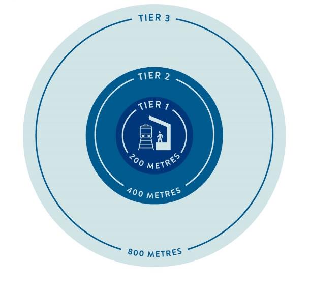
1. SkyTrain Stations
SkyTrain station TOAs include SkyTrain and subway stops, and all
include a catchment area of 800m, measured as a radius from the
centre of each station. SkyTrain TOAs encompass a gross land area
of 200 hectares (ha) and are comprised of three distinct Tiers:
- Tier 1 encompasses a gross land area of 12.5 ha within 200m or less from the station.
- Tier 2 encompasses a gross land area of 37.5 ha greater than 200-400m from the station; and
- Tier 3 encompasses a gross land area of 150 ha greater than 400-800m from the station.
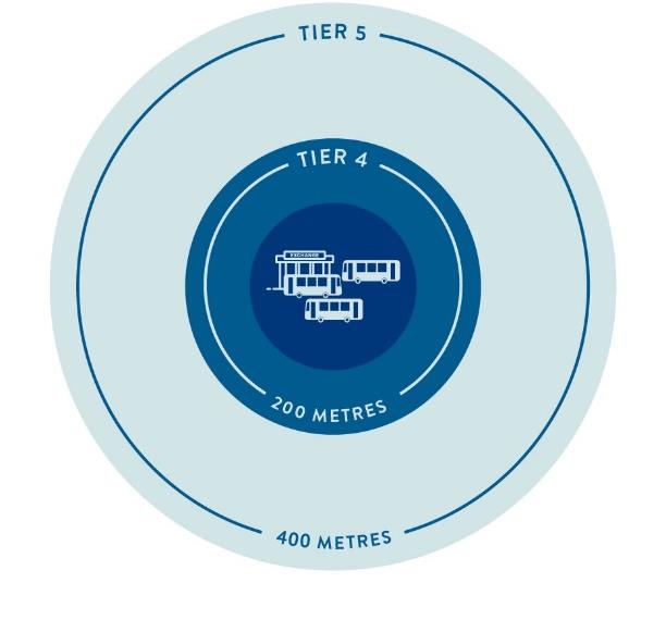
2. Bus Exchanges and West Coast Express Stations (400M)
Bus exchange and West Coast Express station TOAs have a catchment area of 400m. They encompass a gross land area of 50 ha and are comprised of two distinct Tiers:
- Tier 4 encompasses a gross land area of 12.5 ha within the 200m or less from the exchange; and
- Tier 5 encompasses a gross land area of 37.5 ha greater than 200m-400m from the exchange.
All West Coast Express stops are prescribed transit stations. Bus exchange locations were identified based on multiple service and infrastructure criteria, including:
- 15-minute service frequency (between 10am and 3pm, weekdays);
- 2 or more unique line/route connections;
- Service 7 days a week (between 7am and 7pm);
- Permanent, purpose-built infrastructure.
Location Exemptions and Future Considerations
Some transit stations meet the above criteria but have significant site constraints, for example, sites which are not within municipalities' jurisdiction to regulate (ALR, federally regulated lands, etc.), and have been excluded from being prescribed in the TOA regulations.
The TOA legislation and regulations apply to current transit technologies and currently active or under construction transit stations. For example, TransLink plans to deploy Bus Rapid Transit throughout the Metro Vancouver region, but that technology has not been included in the current definitions because it does not yet exist. As transit technologies evolve and as transit services expand across the province, the legislation and regulations will be updated to accommodate those additions.
What are the minimum density requirements in TOAs?
The Province developed the Minimum Allowable Density Framework (MD Framework) that informed the prescribed densities which municipalities must allow when exercising zoning powers in relation to land zoned to permit residential (or any other prescribed) use. The MD Framework is designed to ensure predictable and adequate densities within similar TOA catchment categories.
The MD Framework relies on two metrics to define minimum allowable density:
- Density, measured by Floor Area Ratio (FAR4), and
- Building Height, measured in storeys.
The MD Framework is reflected in a prescribed density table in the regulations that outlines the permissible density (i.e., FAR/FSR and storeys) as applicable, within designated TOAs.
Residential parcels mean properties which include residential uses in their zoning provisions. This includes mixed-use zones where commercial, employment, institutional, or other uses are permitted alongside residential uses.
Per the regulations, parcels which are zoned to permit residential use that is ancillary or secondary to agricultural or industrial uses are exempted from the minimum density requirements.
4 The Vancouver Charter uses Floor Space Ratio (FSR)
The Density 'Envelope'
Zoning bylaws typically contain a maximum permitted density and building heights within each zone and for allowable use. These standards allow a range of building densities and heights up to, but not exceeding, the maximums established in the zone. This approach creates a range of possible densities and heights for rezoning applicants to choose from when planning and designing their project.
Similarly, the MD Framework establishes new minimum allowable densities which municipalities must adhere to when exercising their zoning authority in relation to rezoning applications or amendments to zoning bylaws. These prescribed minimum densities are also established as "up to" regulations. For example, on Tier 1 land within passenger rail (SkyTrain) station TOAs, the minimum allowable FAR/FSR is 5.0 or less and the minimum allowable height is 20 storeys or less. This provides an allowable range or envelope of densities and building heights within TOAs.
However, an important distinction is that while an envelope of allowable densities and heights are available for rezoning applicants to work within, a municipality may not reject a rezoning proposal based on the density or height exceeding what is allowed in a zoning bylaw if what is proposed is less than or equal to the prescribed minimum density or height in the regulations. For instance, if a rezoning applicant proposes a 15-storey project within a Tier 1 TOA that allows 20 storeys per the regulations, but the municipality's zoning bylaw limits density to 2.0 FAR/FSR and 5 storeys, the municipality must not refuse the rezoning application based on height and density alone. Conversely, if an applicant proposes a 22-storey project with an FAR/FSR or 5.0 in the same Tier 1, the municipality could reject the application based on height that exceeds the Provincial minimum.
It is also important to note that municipalities retain the zoning authority to establish densities and heights greater than those prescribed by Provincial regulations.
The MD framework applies to all land area within the TOA and recognizes that there may be instances where an individual site cannot achieve all the allowable density or building height, including:
- A site cannot physically accommodate all the available density or building height (e.g. due to site size, shape, land constraints, etc.).
- Cost considerations of type of construction, building code requirements (e.g. concrete versus wood-frame or mass timber construction).
- Land assembly issues.
The MD Framework works as follows:
| Existing Allowable Density (current zoning) |
|
| MD Framework Density (Provincial Density Envelope) |
|
| Discretionary Additional Increase in Density (Municipal Discretion) |
|
5 In most but not all cases, the MD Framework will set densities above the Existing Allowable Density (current zoning).
THE ILLUSTRATIONS BELOW PROVIDE AN EXAMPLE OF HOW THE PROVINCIAL DENSITY WORKS IN RELATION TO MUNICIPAL AUTHORITY:
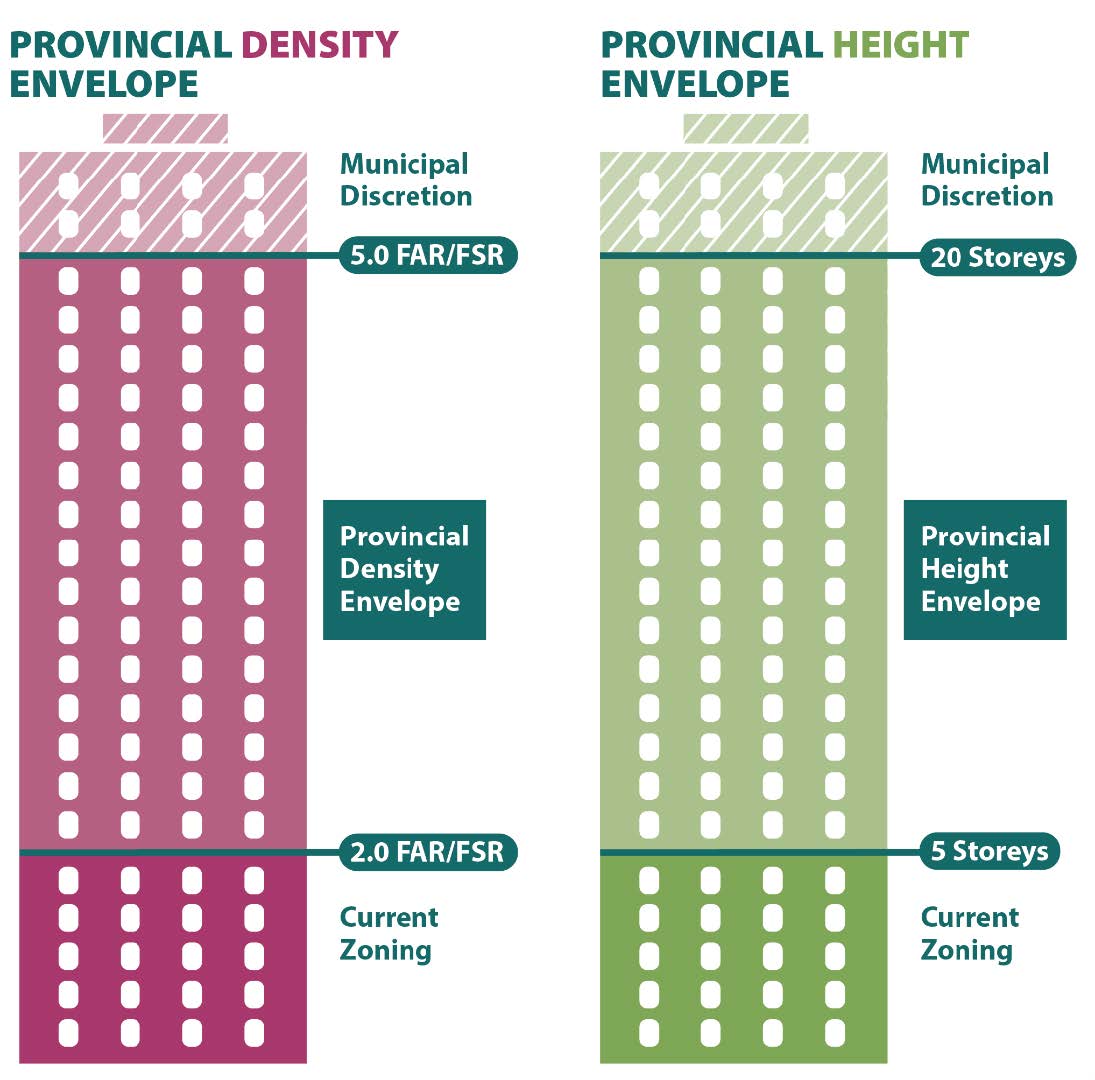
FAR/FSR:
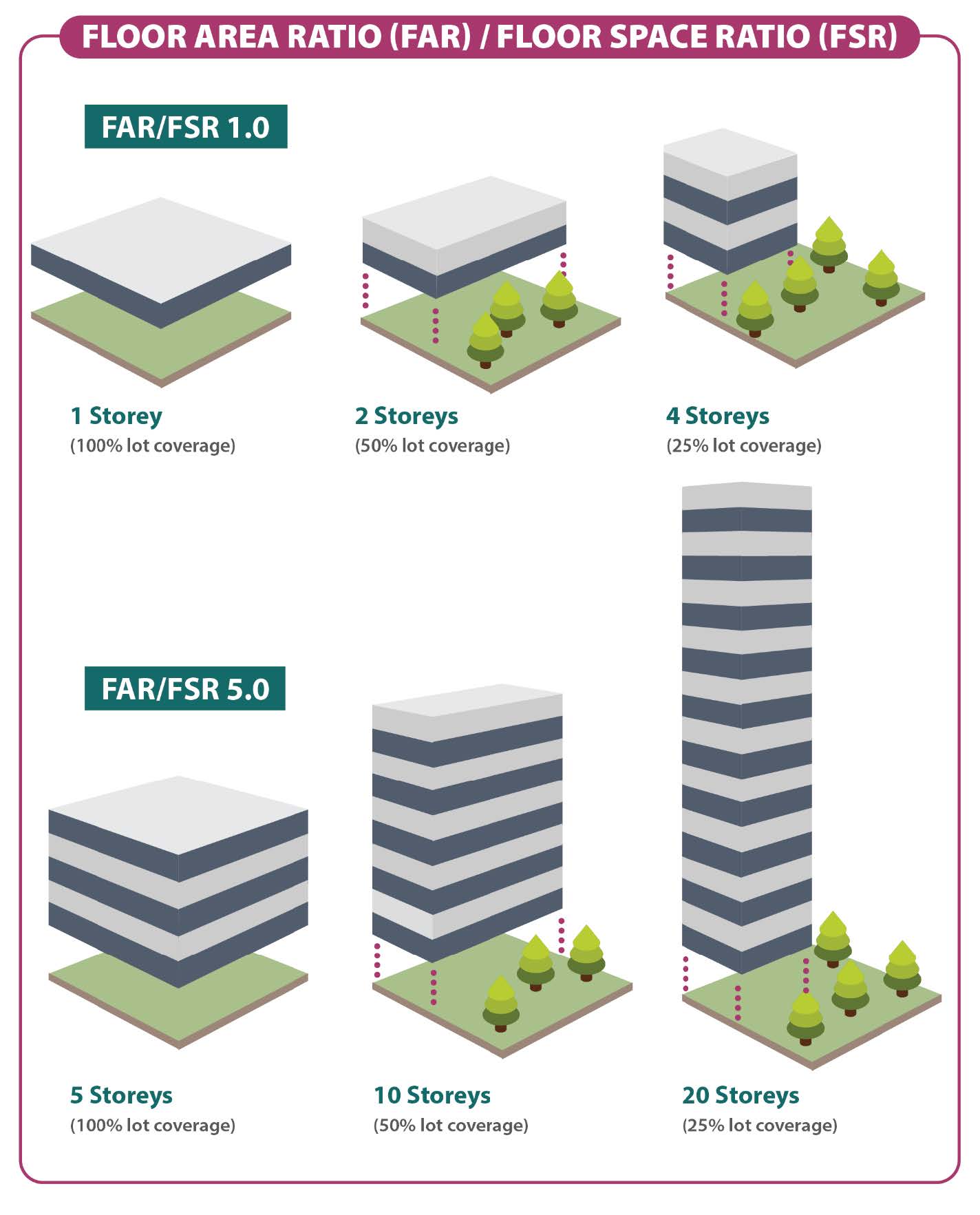
Since FAR/FSR and building height do not directly correspond to one another, the MD Framework has been designed so that the FAR/FSR and building heights listed represent the maximum FAR/FSR and height a municipality is required to allow. For example, if a proposed building has an FAR/FSR which is at the provincial maximum FAR/FSR, but the proposed building height exceeds the provincial maximum height, then the municipality would have discretion to limit the proposal to the provincial maximum height; however, the municipality could not use its zoning authority to restrict or prohibit the maximum FAR/FSR allowed by the regulations.
MINIMUM DENSITY TOA CATEGORIES
The MD Framework aims to achieve viable densities based on transit infrastructure type and the nature of the housing market, population size, land values, and geographic location while also being broadly applied across the province. As such, the MD Framework categorizes land within TOAs into tiers in the regulations to assign different minimum allowable densities. The density prescribed for a tier will vary depending on the type of transit station (i.e., SkyTrain, West Coast Express or bus exchange).
What are the new revisions that apply to off street parking for residential uses within TOAs?
Off-street parking for residential units is often provided underground as part of a development in areas around higher-order transit, often according to set minimums required by municipalities. Land in these areas is often expensive and providing parking underground can be a major cost for higher density residential projects. Minimum parking requirements can strain a project's economic viability, reduce the number of residential units, reduce the affordability of units, and disincentivize residents from utilizing transit. Further, parking garages often go underutilized, resulting in an inefficiently designed building.
Many municipalities have recently considered reducing or eliminating residential off-street parking requirements in proximity to frequent transit or central urban areas.
Beginning June 30, 2024, the new parking legislation restricts municipalities' ability to require residential off-street parking in TOAs, except for parking for people with disabilities. Municipalities must adopt a parking bylaw to reflect this change. This does not eliminate all parking. Municipalities will still be able to require builders and developers to add parking to accommodate people living with disabilities. Commercial parking requirements will not be affected within TOAs. Builders and developers will be able to propose projects that include residential off-street parking but cannot be required to provide it other than parking spaces for use by people with disabilitiesAll existing requirements for off-street parking or space provisions for accessible vehicle parking, bicycle/micro-mobility parking, loading/unloading, service vehicle access, deliveries, and shared vehicles set by municipalities for residential and residential mixed-use developments will still apply. Should a property owner opt to provide off-street residential parking spaces, these spaces must adhere to the design standards established by the respective municipality.
In cases where exceptions to these parking restrictions may be required, the legislation provides the Province with the authority to make regulations to require the provision of off-street parking spaces, for the residential use of the land, building or other structure.
Exemptions and Limitations
The MD Framework applies to any parcel within a TOA on which the applicable zoning permits residential land use. There are two exceptions from TOAs:
- Land zoned to permit residential use that is ancillary or secondary to industrial use.
- Land zoned to permit residential use that is ancillary or secondary to agricultural use.
- Agricultural Land Reserve (ALR)
- Airport Zoning Regulations under Aeronautics Act
- Federal Crown land
- Flood plains, hazard areas, riparian areas and other environmentally sensitive areas; and
- Heritage objects and sites that are subject to heritage designation, heritage revitalization agreements, etc.
Relationship with Other Provincial Legislation
When municipalities designate TOAs, there are provincial statutes or regulations that will need to be considered. It is up to municipalities to determine the legislative and regulatory frameworks that apply to a given parcel prior to approving development.
The Transportation Act governs public works related to transportation, as well as the planning, design, holding, construction, use, operation, alteration, maintenance, repair, rehabilitation, and closing of provincial highways. It also provides authority to designate arterial and controlled access highways.
Under Section 52 of the Transportation Act, a controlled area is defined as any land and improvements within an 800-metre radius of the intersection of a controlled access highway with any other highway. A municipality zoning bylaw does not apply to the controlled area unless it has the written approval of the Minister of Transportation and Infrastructure or delegate, or the bylaw is compliant with an agreement under the signature of the Minister or delegate. Zoning amendments to implement the TOA legislation in controlled areas as defined in the Transportation Act will require the written approval of the Minister of Transportation and Infrastructure or delegate unless compliant with an existing agreement.
Relationship with Other Provincial Initiatives
A number of legislative requirements and tools were introduced in the fall of 2023 and spring of 2024 that impact planning, reporting, and development approval processes for local governments in British Columbia. These legislative changes are designed to respond to challenges communities across the province are experiencing, including a shortage of safe and affordable housing.
These legislative changes are summarized below. They were implemented in conjunction with the TOA legislation to collectively modernize land use planning processes; support the supply, diversity, and affordability of housing; and help equip local governments with the tools needed to sustainably manage their services and infrastructure. They support the Homes for People Action Plan, which strives to speed up the delivery of new homes and increase the supply of attainable housing.
Many of the legislative changes described below originated from the Province's Development Approvals Process Review which began in 2018. It was undertaken with the goal of increasing the efficiency and effectiveness of local government development approvals processes. The extensive stakeholder consultation that informed the resulting report highlighted several systemic challenges these initiatives are designed to address.
Housing Needs Reports
In fall 2023, the Province changed legislative requirements related to local governments' preparation of housing needs reports (HNRs). When updating their HNR every 5 years, local governments are now required to use a standard methodology and calculate housing needs over a longer 20-year time horizon, as well as the 5-year timeline originally required. The requirements also more directly link housing needs reports to official community plans and zoning bylaws to ensure both planning and zoning align with community housing needs.
Linkages Between Official Community Plans and Zoning Bylaws
Official community plans (OCPs) describe the long-term vision of communities. They include statements of objectives, maps, and policies that guide decisions on local government planning and land use management. Zoning bylaws are intended to implement land use planning visions expressed in OCPs and regional growth strategies by regulating how land, buildings, and other structures may be used.
The fall 2023 legislative changes introduced new requirements for municipalities (not regional districts or the Islands Trust) to align their OCPs and zoning bylaws with HNRs. By December 31, 2025, municipalities must have updated their OCPs to include statements and map designations to accommodate anticipated housing needs over at least 20 years, as well as housing policies covering all seven classes of housing needs identified in HNRs. They must also have updated zoning bylaws to pre-zone for the 20-year total amount of housing needed. Future OCPs and zoning bylaw reviews are required by December 31, 2030 and then every five years. The Proactive Planning Guidance provides more detail on these requirements.
Over time, this will have the effect of reducing the number of site-specific rezoning applications required to bring into effect land use changes that are consistent with community visions articulated through OCPs. Development permit applications will still be needed, as well as building permits. This will assist communities in realizing their vision for growth and change sooner.
When updating OCPs and zoning bylaws to meet these new requirements, municipalities should consider how TOAs factor into their approach. While there is no requirement to proactively zone TOAs, doing so, either in part or in full, can help facilitate development and support housing delivery goals. Importantly, the minimum allowable densities and heights established by the Province within TOAs do not automatically count toward meeting zoned capacity requirements. To include TOAs in zoned capacity calculations, municipalities must take the additional step of pre-zoning. Given their strategic location and potential to support growth, municipalities are encouraged to assess where within their TOAs it is most advantageous to pre-zone.
The intent of the TOA legislation and associated regulations is to enable minimum densities when municipalities make zoning decisions. Municipalities can turn down rezonings for reasons other than density, such as the preservation of heritage buildings and features. For example, in the case of Vancouver, which relies heavily on zoning authority to protect heritage buildings and features, Council may continue to regulate other aspects of a development (architectural expression, form of development, etc.) through their zoning authority to ensure any new development or additions are compatible and appropriate to the unique historical or cultural context of the district.
Small Scale Multi-Unit Housing Initiative
In the fall of 2023, the Province also introduced changes to the Local Government Act and Vancouver Charter to allow more small-scale, multi-unit housing (SSMUH) in zones that are otherwise restricted to single family dwellings and/or duplexes.
Through the SSMUH legislation, the Province enabled secondary suites or accessory dwelling units (ADUs) on single-family zoned lots throughout BC. In suburban and urban communities, the legislation requires multiple units of housing (3 to 6 units depending on the location and context) to be permitted on single-family and duplex zoned lots. As a result of this, local governments must ensure their zoning bylaws permit a minimum density of two units or three to six units of housing on lots identified in Restricted Zones as that term is defined by the legislation.
The SSMUH provisions are designed to increase housing supply, create more diverse housing choices, and over time, contribute to more affordable housing across BC.
It is important to note that properties within a designated Transit-Oriented Area are exempt from the requirements to zone for 3 to 6 units under the SSMUH legislation. Properties within a TOA will be subject to higher density requirements in accordance with the TOA legislation and regulations to help improve transit viability and service.
The Provincial Policy Manual & Site Standards provides more detail on the SSMUH legislative framework.
Development Financing
The TOA legislation is intended to help facilitate housing supply, which will likely create demand for new or expanded infrastructure from local governments. To address this demand, local governments have a range of financing tools available to acquire and construct new infrastructure and amenities. The key development finance tools set out in legislation include development cost charges (DCCs), and in the case of City of Vancouver, development cost levies (DCLs) and new provisions for amenity cost charges (ACCs).
Development Cost Charges
DCCs/DCLs can be levied on new development to help pay the capital costs of new or expanded infrastructure, such as sewer, water, drainage, parks, and roads necessary to adequately service the demands of that new development. The LGA sets out the rules and requirements for using DCCs and the VC sets out the rules and requirements for using DCLs.
A new or amended DCC/DCL bylaw will also be required if a local government wishes to collect DCCs/DCLs to help pay the capital costs of fire protection facilities, police facilities and solid waste and recycling facilities, or if the updates to zoning regulations affect the assumptions used to calculate DCCs/DCLs, such as the number of residential units, housing stock mix, or occupancy rates. The same rules and requirements that exist in the DCC/DCL framework will apply to these new categories. The Development Cost Charges Best Practices Guide provides more detail for local governments seeking to develop or update DCC/DCL bylaws.
Amenity Cost Charges
Local governments can also use the new ACC tool to help pay the capital costs of amenities (e.g., community and recreation centers, libraries, day care facilities) needed to support growth and create liveable communities. Note that ACCs cannot be used to pay the capital costs of projects that are eligible to be funded through DCCs/DCLs.
Like DCCs/DCLs, ACCs must be imposed by bylaw. Local governments must determine the area or areas in their communities where they are anticipating growth and identify what amenities are needed in the area(s). When determining the area(s) and amenities, local governments will need to consider their OCPs and other relevant planning documents, expected increases in population, and the financial plan. The Amenity Cost Charge Best Practices Guide provides more detail for local governments seeking to develop or update ACC bylaws.
Density Bonus and Inclusionary Zoning
Density bonus (DB) and inclusionary zoning (IZ) are tools that local governments can use to secure public benefits through new development, serving distinct purposes. DB is an existing tool that allows local governments to offer additional (“bonus”) density in exchange for amenities and/or affordable housing. In contrast, IZ is a new authority introduced in spring 2024 that enables local governments to require that a portion of new housing in eligible developments be affordable. Both tools are now subject to financial feasibility requirements and implementation guardrails so that they do not deter development. The Inclusionary Zoning and Density Bonusing Comprehensive Guidance provides more detail for local governments seeking to develop or update DB/IZ bylaws.
Municipalities can continue to use DB in TOAs, including within the minimum allowable densities, until June 30, 2026. This means they may set base densities below the minimum allowable densities and offer bonus density up to or above the minimum allowable densities in exchange for amenities or affordable housing.
After June 30, 2026, DB may only be applied above the minimum allowable densities. At that point, municipalities will need to ensure they have the appropriate tools in place to secure amenities and affordable housing within the minimum allowable densities – namely, ACCs for amenities and IZ for affordable housing.
With DB no longer permitted within the minimum allowable densities after June 30, 2026, IZ will become the primary tool available to municipalities for securing affordable housing through development that occurs within the minimum allowable densities.
Requiring Works and Services, Land for Transportation Infrastructure, and Transportation Demand Management
As of April 2024, local governments have a range of new and expanded authorities to ensure the successful implementation of new housing legislation. These authorities ensure local governments can secure key outcomes outright, rather than through rezoning.
- Expanded works and services authorities:
- An expanded list of works and services that local governments can require, including:
- highways, sidewalks, boulevards, boulevard crossings, street lighting, transit bays or underground wiring;
- amenities, including benches, bollards, bicycle parking facilities, directional signage, parklets, street lamps, street signs, transit shelters or waste disposal and recycling containers;
- transportation infrastructure that supports walking, bicycling, public transit or other alternative forms of transportation, including traffic calming measures;
- sustainable design features that provide for energy and water conservation, reduction of greenhouse gas emissions and climate resilience; and
- Clearer authority for municipalities to require works and services for infill developments that do not involve a subdivision process, by allowing them to use these authorities at the building permit stage.
- The legislation requires that local governments not use the works and services authority to prevent development to the density permitted under applicable zoning bylaws.
- Clearer authority for municipalities to also require land be provided without compensation for roads at the building permit stage6 (in addition to at subdivision):
- To provide a portion of land for new or widening of existing roads as a condition of building permit (up to 20 m in depth).
- New authority to require land be provided without compensation for sustainable design features and alternative forms of transportation at subdivision7 (regional districts and municipalities) or building permit stage (municipalities)8 :
- To provide more land (up to an extra 5 m in depth) for constructing and installing sustainable design features and transportation infrastructure that supports walking, bicycling, public transit or other alternative forms of transportation. This can include things like wider sidewalks, bike lanes, street trees, rain gardens, and traffic calming that cannot be accommodated within current limits. This 5 m is in addition to the 20 m that can be required for new or widening of existing roads.
- Transportation Demand Management (TDM) authorities to define and require TDM measures in new developments9. TDM measures include charging stations, secure bicycle and scooter parking facilities, and end-of-trip facilities (see Table 4 for examples of on-site and off-site transportation demand management measures that developers and local governments can provide).
The Province expects that these new and expanded authorities will be of most use in cases of ‘infill’ development (i.e., development that is occurring in existing neighbourhoods), including within TOAs.
Local governments can only use these authorities through bylaw. To ensure a strong planning and policy foundation, the LGA now clearly provides the option to include specific OCP policies relating to alternative forms of transportation (walking, cycling, public transit) and to TDM.
For more information about site-level infrastructure and transportation demand management (TDM) authorities refer to the local government housing initiatives webpage.
6 To exercise this authority at the building permit stage, a municipality must first designate a
“servicing officer”. Section 3 of the Planning and Land Use Management Regulation prescribes the classes of persons that can be designated “servicing officers”, including: municipal engineers;
municipal chief planning officers (or persons in a substantially equivalent position); other
employees of the municipality designated by the council, or persons who are under contract with
the municipality.
7 Provincial Approving Officers are responsible for reviewing and approving all subdivisions in rural
areas outside of municipalities. A regional district must request a Provincial Approving Officer
require land be provided for new or widening of existing roads and/or alternative forms of
transportation as a condition of subdivision on their behalf.
8 To exercise this authority at the building permit stage, a municipality must first designate a
“servicing officer”. Section 3 of the Planning and Land Use Management Regulation prescribes the
classes of persons that can be designated “servicing officers”, including: municipal engineers;
municipal chief planning officers (or persons in a substantially equivalent position); other
employees of the municipality designated by the council, or persons who are under contract with
the municipality.
9 Local governments now have the option to introduce a cash in-lieu option for TDM measures. For
cases where on-site TDM measure are not possible (e.g., small building footprint), this option allows
local governments to fund the measures at sites nearby. Cash in-lieu payments must be kept in a
reserve fund for the purpose of supporting new or existing TDM measures.
Tenant Protection Bylaws
Spring 2024 legislation provided municipalities with the explicit authority to establish Tenant Protection Bylaws (TPBs), enabling them to require added supports for tenants who may face displacement due to redevelopment. These supports can include financial assistance, moving support, help finding alternative housing, or the right to enter into anew tenancy agreement with the owner in the redeveloped building or another building. The Provincial Policy Manual: Tenant Protection Bylaws provides more detail for municipalities seeking to develop TPB bylaws. As redevelopment and densification occur in TOAs, TPBs provide municipalities with a tool to help ensure that tenants in TOAs are supported through these changes. Municipalities should consider how TPBs can be applied in TOAs, particularly in areas with older purpose-built rental housing, where redevelopment may be more likely. Applying TPBs in TOAs can help maintain community stability and support equitable outcomes as new housing is introduced.
Part 2 – Implementing the Legislation and Regulations
Overview
As of June 30, 2024, all 104 TOAs are in effect in 31 municipalities. The MD Framework places a restriction on zoning decisions in relation to density, size, or dimension of buildings or structures. Municipalities may continue to develop and amend official community plans or development plans for areas around prescribed stations. However, as these plans are created and amended over time, municipalities must ensure that they align land use designations with the MD Framework. In addition, these plans may include overall metrics, such as total capacity for housing supply or employment targets within the TOA and would consider all land uses within the TOA, account for local market conditions, and plan for the provision of services and amenities required to support a community.
Rezoning Process
There is no requirement to pro-actively zone to the prescribed heights and densities in TOAs. The MD Framework does not change the existing rezoning process of a municipality. Application fees, submission requirements, staff reporting, bylaw introduction and readings, and final adoption are not affected by this legislation or the regulations. Only density and height requirements are imposed by the new framework.
However, as municipalities are working to comply with the other legislative requirements to ensure that housing needs identified in their most recent housing needs report are accommodated in official community plans and zoning bylaws, they may choose to prioritize some or all areas within TOAs for pro-active zoning. Municipalities pro-actively zoning in TOAs must align zoning changes to the MD Framework.
Where do the New Requirements Apply?
The regulations identify the locations of prescribed transit stations. Municipalities must use the Order-in-Council that amends the Local Government and Vancouver Transit Regulations, effective June 30, 2024, for the purposes of designating TOAs by bylaw.
The Province has identified 31 municipalities that must designate TOAs:
| City of Abbotsford | District of Lantzville | City of Port Coquitlam |
| City of Burnaby | City of Maple Ridge | City of Port Moody |
| City of Chilliwack | City of Mission | City of Richmond |
| City of Colwood | City of Nanaimo | District of Saanich |
| City of Coquitlam | City of New Westminster | City of Surrey |
| City of Delta | City of North Vancouver | City of Vancouver |
| City of Kamloops | District of North Vancouver | City of Vernon |
| City of Kelowna | City of Penticton | Town of View Royal |
| City of Langford | City of Pitt Meadows | City of Victoria |
| City of Langley Township of Langley |
City of Prince George | Resort Municipality of Whistler |
Note: The District of Lantzville and the City of Delta do not contain prescribed transit stations. However, the prescribed transit station is in an adjacent municipality and the TOA catchment area crosses the municipal boundary.
Step-by-Step Guidance
Below is a step-by-step guide for municipalities to appropriately designate TOAs and permit the minimum allowable densities prescribed in the regulations.
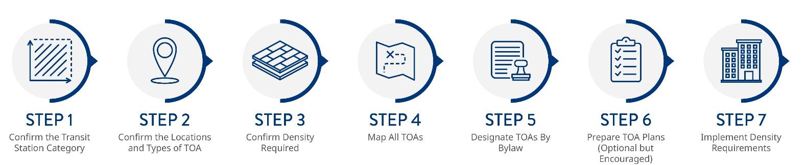
Step 1 – Confirm the Transit Station Category
Transit stations differ based on transit technology (bus, West Coast Express and SkyTrain); municipalities with both bus/West Coast Express (WCE) and SkyTrain TOAs may have more than one type of transit station, and therefore, will have more than one type of TOA.
Municipalities should first confirm their transit station type in Table 1. This table is provided for convenience. Municipalities should refer to the regulations to confirm the prescribed transit stations and densities that are applicable in their jurisdictions.
Table 1: Categories of Transit Station Types Required to Designate TOAs
| CATEGORY | APPLICABLE MUNICIPALITIES |
|---|---|
| Category 1 SkyTrain in Metro Vancouver | Burnaby, City Coquitlam, City Langley, City Langley, Township New Westminster, City Port Moody, City Richmond, City Surrey, City Vancouver, City |
| Category 2 Bus Exchange or West Coast Express in Metro Vancouver | Delta, City Langley, City Maple Ridge, City North Vancouver, City North Vancouver, District Pitt Meadows, City Port Coquitlam, City Surrey, City Vancouver, City |
| Category 3 Bus Exchange or West Coast Express in Capital region and other medium sized municipalities | Abbotsford, City Chilliwack, City Colwood, City Kamloops, City Kelowna, City Langford, City Mission, City Nanaimo, City Prince George, City Saanich, District Vernon, City Victoria, City View Royal, Town |
| Category 4 Bus Exchange in smaller sized municipalities |
Lantzville, District Penticton, City Whistler, Resort Municipality |
Step 2 – Confirm the Locations and Types of TOA
Confirm TOA locations and types: The Province has identified TOAs across BC and municipalities must determine which TOAs are within their jurisdiction. A comprehensive list of all provincially prescribed transit stations for designation as TOAs can be found in the regulations.
Confirm catchment area: On average, most people will walk approximately ten minutes to SkyTrain and approximately five minutes to access frequent bus service. These walk times coincide with an 800-metre radius and 400-metre radius, respectively, and are referred to as the catchment area.
Municipalities identify catchment areas for each TOA station location. SkyTrain TOAs have a prescribed distance of 800m, and Bus Exchange and West Coast Express TOAs have a prescribed distance of 400m.
| TOA Types | Catchment Area (Metres) |
| SkyTrain TOA | 800m |
| Bus Exchange or West Coast Express TOA | 400m |
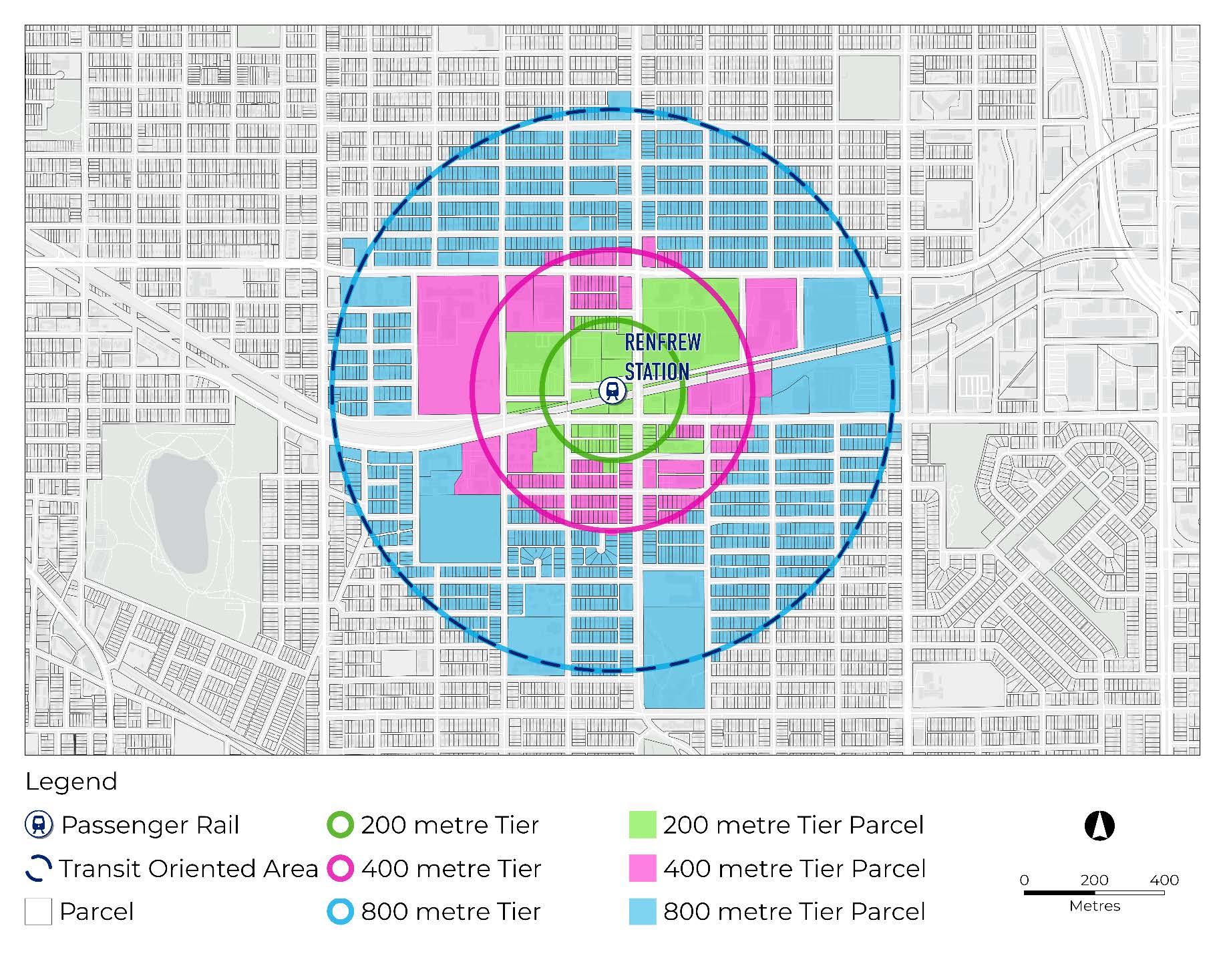
Municipalities will be responsible for mapping their catchment areas. Coordinates for prescribed transit facilities are included in the regulations. These coordinates should be used as the centre point, from which a 400m or 800m radius will be drawn to establish the catchment area. Any parcel which is partially included in the catchment area is deemed to be wholly within the catchment area of that TOA. See example below:
Catchment Area Map Example:
(For illustration only, not to be relied upon for accuracy.)
Cross-Jurisdictional TOAs
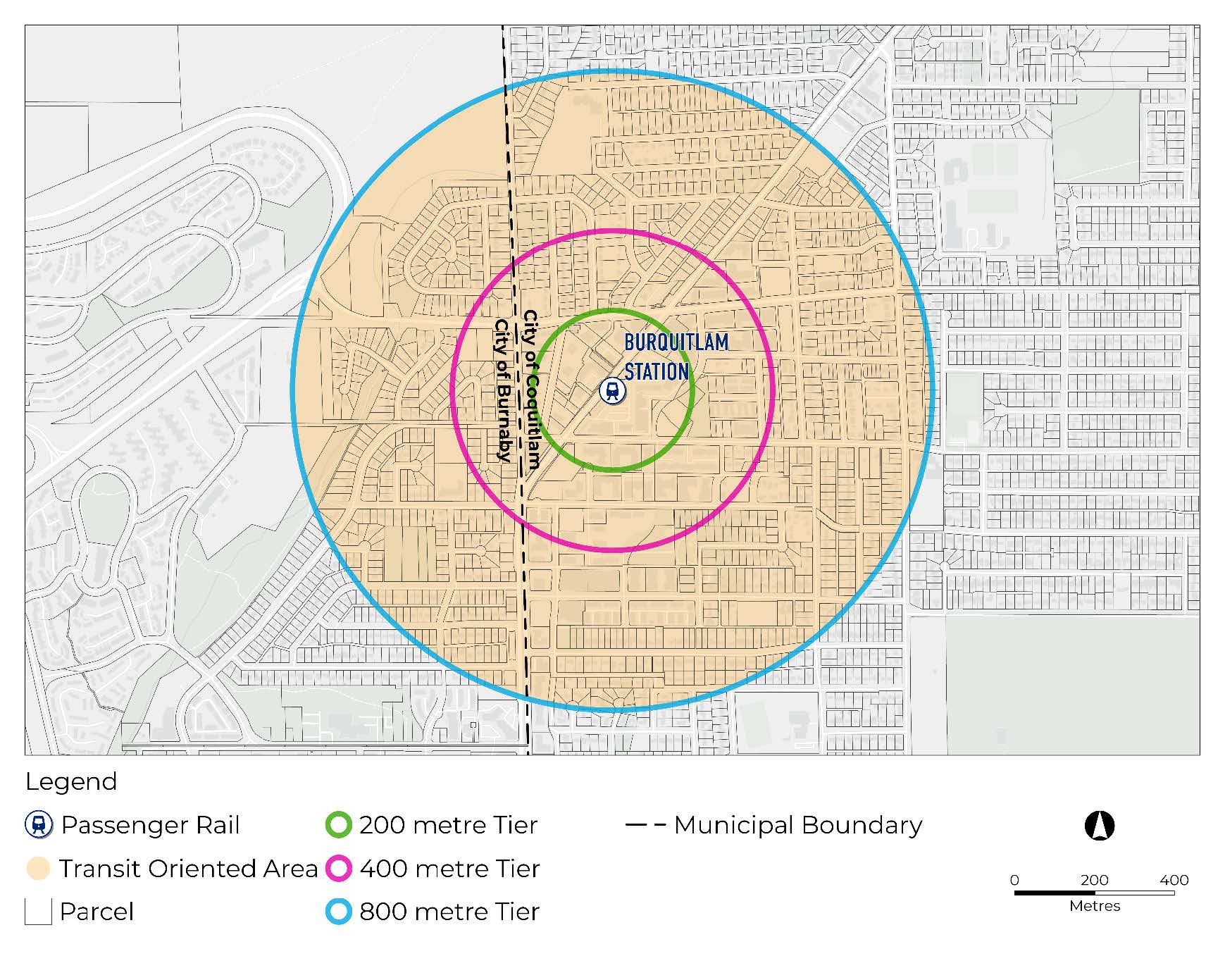
Some TOAs cross municipal boundaries. The municipalities that should designate these TOAs are listed in the regulations. In these cases, municipalities will be responsible for designating the portion of the TOA that is within their jurisdiction.
Step 3 – Confirm Density Required
The density tables in the regulations outline the permissible density envelopes (i.e., FAR/FSR and Building Height) applicable to all residential zoned parcels within designated TOAs. Table 2 provides the FAR/FSR and building height parameters for each TOA Type and Tier as per the regulations.
The density table refers to the categories of municipalities outlined in Table 1 and the transit technology (Passenger Rail or Bus Exchange/West Coast Express) outlined in Step 2. Municipalities should use the Tables in the regulations to identify the density requirements which apply within a given TOA. Notably, Passenger Rail (e.g. SkyTrain) densities are broken out into three 'Tiers' (Tier 1, 2 and 3) and bus and West Coast Express densities are broken out into two 'Tiers' (Tier 4 and 5). See Table 2 below.
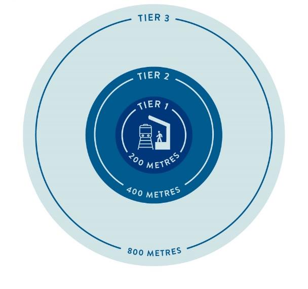
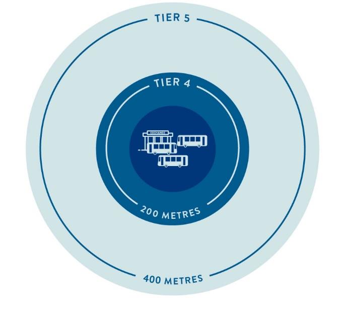
Table 2: Minimum Allowable Density Framework (FAR/FSR and Building Height)
| Category | Tier | Prescribed Distance (Metres) |
Minimum Allowable Density (FAR/FSR) | Minimum Allowable Height (Storeys) |
| Category 1: SkyTrain in Metro Vancouver | 1 | 200 or less | Up to 5.0 | Up to 20 |
| 2 | Greater than 200-400 | Up to 4.0 | Up to 12 | |
| 3 | Greater than 400-800 | Up to 3.0 | Up to 8 | |
| Category 2: Bus/WCE in Metro Vancouver | 4 | Less than 200 | Up to 4.0 | Up to 12 |
| 5 | Greater than 200-400 | Up to 3.0 | Up to 8 | |
| Category 3: Bus/WCE | 4 | 200 or less | Up to 3.5 | Up to 10 |
| 5 | Greater than 200-400 | Up to 2.5 | Up to 6 | |
| Category 4: Bus | 4 | 200 or less | Up to 2.5 | Up to 6 |
| 5 | Greater than 200-400 | Up to 1.5 | Up to 4 |
Table 2 is provided for convenience purposes only. Please refer to the regulations when determining the density applicable to a given TOA.
Similar to mapping the outer border of a TOA, the 200m and 400m Tiers of a TOA must be measured from the coordinates provided in the regulations. Where parcels are bisected by two different density Tiers, the parcel is deemed to be wholly within the class of land to which the highest density applies.
The density table does not reduce or limit the density, size, or dimension permitted in existing zones established by municipalities. Many municipalities already allow higher densities than those listed in the density table and are encouraged to continue to do so.
Overlapping TOAs – Determining density
In some areas, TOAs will overlap due to transit station spacing. In these cases, the highest density applicable to a geographic area is the density level which must be applied.
A development proposal in an area where two TOAs overlap would be subject to the higher density and height, not a sum of the density and height of each of the overlapping TOAs. Municipalities continue to have discretion to permit density and height above the minimun allowable.
Step 4 – Map All TOAs
As noted above, bylaws designating a TOA must include a map showing each TOA boundary. The map must include the TOA type and tiers using the distances prescribed in Step 3 above.
Since TOAs are a prescribed distance of 400m or 800 m from transit stations, some TOAs may overlap with bodies of water, First Nations treaty lands, the Agricultural Land Reserve, federally regulated lands such as ports and airports, or heritage sites under the Heritage Conservation Act. In these cases, municipalities may identify parcels where the densities in the regulations do not apply for greater certainty.
Step 5 – Designate TOAs By Bylaw
Municipalities must designate each TOA with a catchment area within its jurisdiction by bylaw by June 30, 2024. There is no requirement to amend the zoning bylaw or official community plan bylaw to designate TOAs, but the bylaw must contain a map showing the boundaries of each TOA. The regulations prescribe transit stations in relation to which municipalities must designate TOAs and specifies which geographic coordinates to use for the purpose of designating TOAs.
The Local Government Transit-Oriented Areas Regulation and the Vancouver Transit-Oriented Areas Regulation will be amended effective June 30, 2024.
The limitation on density will apply immediately to TOAs around transit stations which are prescribed with an effective date of December 7, 2023, even if they haven’t yet been designated a TOA by bylaw. Municipalities are required to designate TOAs around prescribed stations within their municipal boundaries by June 30, 2024, and the limitation on the use of zoning powers will apply in those TOAs once designation by bylaw has occurred.
The municipalities subject to interim TOA designations are those with existing OCP or ODP policies which contain a commitment to supporting transit-oriented development.
At the time of the enactment of the legislation and the regulations, the Province identified 46 transit-supportive policies. Where prescribed transit stations coincide with an existing policy, the requirements of the regulations limiting municipalities' use of zoning powers within the prescribed distance of that transit station apply on December 7, 2023. To reduce uncertainty, these locations are provided in a map format in the Designation of Transit-Oriented Areas Regulation. In most cases, the geographies of existing policies will differ from the 400m and 800m catchment areas of provincially prescribed TOAs. In these instances, the boundary of the provincially prescribed TOA is the boundary within which the MD Framework will immediately apply. Municipalities will be expected to designate these areas by bylaw by June 30, 2024.
Step 6 – Prepare TOA Plans (Optional but Encouraged)
Municipalities are strongly encouraged to prepare a Transit-Oriented Area Plan (TOA Plan) for all designated TOAs. In some circumstances, the TOAs identified in the regulations will form part of an existing municipal transit supportive policies or other land use plans and only text and/or boundary amendments will be required. In TOAs without existing transit supportive policies, municipalities can identify their TOA boundaries according to the regulations.
Step 7 – Implement Density Requirements
The Provincial density requirements are minimum allowable densities that establish an 'envelope' for development that cannot be denied on the basis of the density being too high if the density is within the Provincial envelope. Municipalities retain discretion to approve a higher density and/or height than the Provincial density requirements.
Eligible sites within a TOA meet all the following requirements:
- The site is zoned for all or partial residential use.
- The site is not an exempt site (see Step 4).
- The municipality has jurisdiction over land use decisions.
- For an eligible site within a TOA, a municipality must not reject a rezoning application on the basis of the proposed density and/or building height if the density and height are both at or under the density and height specified in the Regulation.
- For an eligible site within a TOA, a municipality, at its discretion, may approve a rezoning application that exceeds the permissible density envelope (i.e., FAR/FSR and Building Height) specified in the regulations.
Transitional Provisions
The requirements and restrictions in the TOA legislation do not apply with respect to any in-stream zoning bylaws amendments that have received First Reading by their respective municipality before December 7, 2023.
Compliance
Municipalities that do not comply with the designation requirements may have a regulation that designates the TOAs in their municipality imposed. Prior to making a recommendation to the Lieutenant Governor in Council, the Minister must notify the municipality of the recommendation and provide at least 90 days municipality for the to designate the TOA. If a TOA designation by regulation is made, the bylaw by which the municipality designated TOA(s) is deemed to be amended to the extent necessary to reflect the TOA designated by regulation.
Appendix A
Appendix A – Definitions and Abbreviations for terms used in this Manual.
- Bus Exchange – off-street bus exchanges where buses park temporarily, and passengers transfer from one line to another.
- Floor Area Ratio/Floor Space Ratio (FAR/FSR) – ratio of a building's total gross floor area, minus the permitted exclusions, to the total parcel size upon which it is built.
- Minimum Density (MD) – minimum FAR/FSR and building height values that must be allowed in each TOA.
- Passenger rail – Rail-based public transport systems including SkyTrain and West Coast Express. Note that in the regulations, passenger rail is often referred to as "passenger rail other than a West Coast Express Station," in these instances, the regulations refer to SkyTrain only.
- SkyTrain – The Expo Line, Millennium Line and Canada Line in Metro Vancouver.
- Transit supportive policies – policies adopted by an elected municipality that guides future development within a designated TOA.
- Transit Station – any of the following facilities, when
prescribed in regulation:
- A bus stop
- A bus exchange
- A passenger rail station (SkyTrain or West Coast Express)
- Other prescribed transit facility, including planned facilities
- Transit-Oriented Area (TOA) – geographic area within a prescribed distance from a transit station as defined by provincial regulation.
- Transit-Supportive Density – density, variety, and patterns of land uses around prescribed transit stations aimed at creating and maintaining transit-supportive conditions.
Disclaimer: For your convenience, Quickscribe has published this searchable HTML version of the TOA Policy Manual. Users are encouraged to visit the Ministry of Housing website to learn additional information about this manual and to access the official PDF version.
This material and all of the information it contains is provided "as is" without warranty of any kind, whether express or implied. All implied warranties, including, without limitation, implied warranties of merchantability, fitness for a particular purpose, and non-infringement, are hereby expressly disclaimed. Links and references to any other websites are provided for information only and listing shall not be taken as endorsement of any kind. Neither the Government of British Columbia, nor Quickscribe Services Ltd. is not responsible for the content or reliability of the linked websites and does not endorse the content, products, services or views expressed within them. Under no circumstances will the Government of British Columbia nor Quickscribe Services Ltd. be liable to any person or business entity for any direct, indirect, special, incidental, consequential, or other damages based on any use of this material including, without limitation, any lost profits, business interruption, or loss of programs or information, even if the Government of British Columbia or Quickscribe Services Ltd. has been specifically advised of the possibility of such damages.